How Pebbles Become a Beach of Their Own
How pebbles become a beach of their own: read size bands, ridges and hollows to make careful field notes without mistaking a clue for a cause.
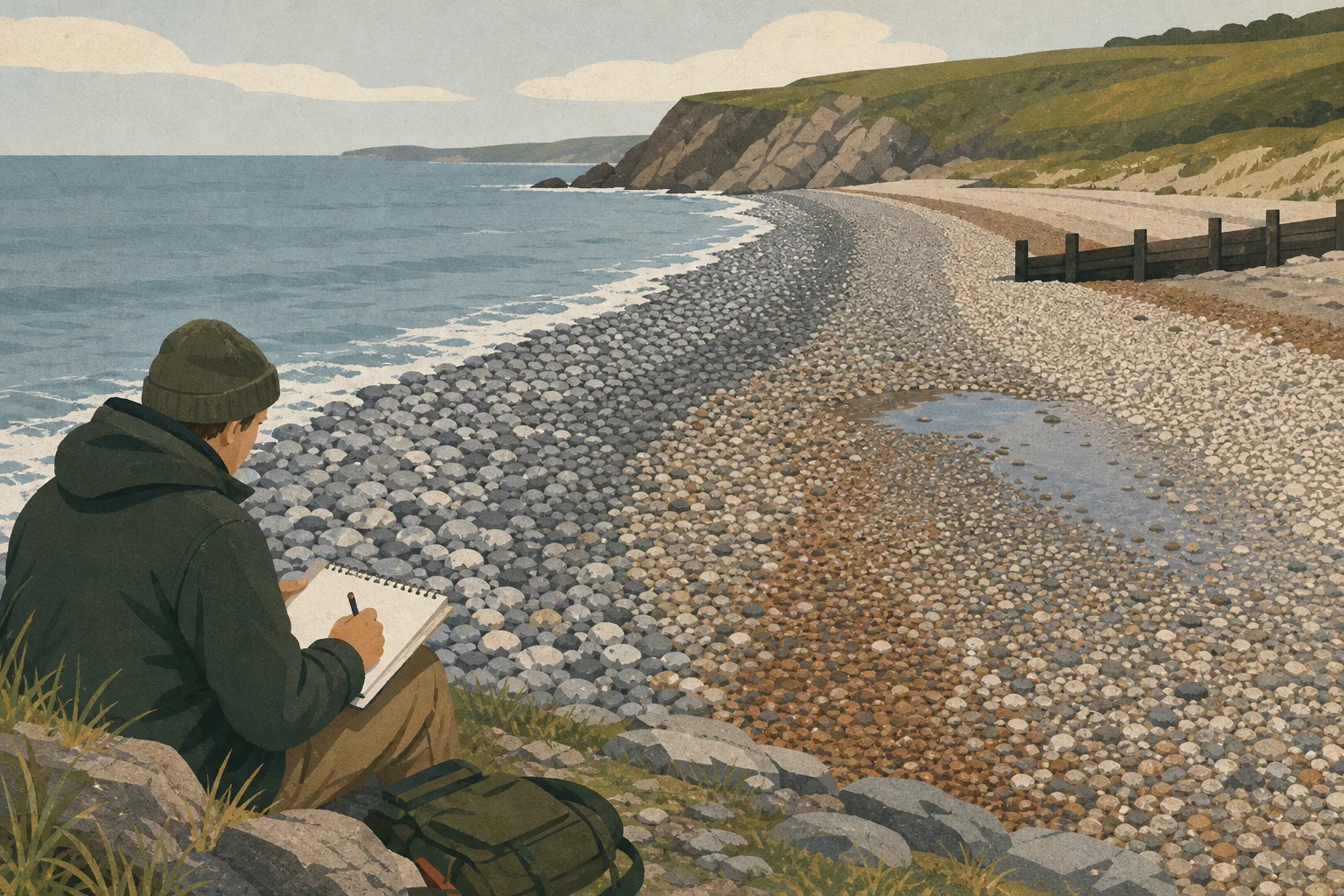
How pebbles become a beach of their own is a question you can begin to answer by looking closely at a single stretch of shingle. Compare the stones’ sizes and shapes, the slope beneath them and the features that interrupt the beach; each offers a clue, but none tells the whole story alone.
Choose a firm viewpoint above the active water and record what is visible without moving stones. A simple sketch can show where a band begins or a ridge bends, details that are easy to overlook in a general photograph.
Read the beach face
The beach face is the sloping part of the shore where waves run up and drain back. Its shape varies with the sediment and recent conditions. Loose or wet stones can shift underfoot, so observe from stable ground rather than walking across a steep or unsettled section.
Start with the broad form: a raised ridge, a lower hollow or a change in slope. A ridge may be a deposit left by waves, while a hollow may collect finer sediment or water. Those are possible explanations, not diagnoses; the same form can arise under different local conditions.
Compare stone bands
Note whether the change from fine gravel to larger cobbles is gradual or sharply defined. Water movement can sort and rearrange sediment, but the result depends on stone size, shape, density, wave direction and the force of the flow. A distinct band is worth mapping; it does not identify its cause by itself.
Stone shape provides another clue. Angular fragments beside a cliff or stream may be associated with nearby material, while rounded stones may have experienced repeated abrasion. Neither appearance proves a precise source or journey: stones can be moved, mixed and reshaped along the coast.
Think of the surface like a tray of mixed buttons gently shaken: smaller pieces may settle into gaps, while larger ones may be harder to move. A beach is less orderly, because wave direction and strength change and the supply of sediment is not uniform.
Trace ridges and hollows
Waves can leave stones near the upper reach of their run-up, forming a ridge. Later waves can alter it, and the ridge’s position also reflects the slope and the sediment available. Hollows may hold finer gravel, sand or water, but their presence does not show exactly how they formed.
Say you visit a cove after rough weather and record a ridge of large stones beside a hollow of finer gravel. You sketch their positions and note that the stones are damp. On a return visit, you see that the hollow’s outline remains but the gravel has shifted. The observable result is a changed surface; the notes cannot, on their own, distinguish wave action from runoff or a change in sediment supply.
Consider possible sources
Pebbles may come from eroding cliffs, river deposits, older beaches or material carried along the coast. A stream can deliver gravel, and a cliff can supply fragments, but either source may be absent, distant or only part of the explanation. Waves may then move or reshape the material.
Groynes and other coastal structures can affect the movement of sediment along a shore. If a change in material appears beside one, record the association without assigning cause: shelter, seabed shape and the local supply of stones may also differ across a short distance.
Make useful field notes
For each observation, write down the visible clue and the decision it supports. If the clue is unclear, record that uncertainty instead of filling it with a guess.
- Check whether your viewing ground is firm and set back from wave run-up; if it is, observe from there, but if it is loose or exposed, move to firmer ground.
- Check whether a ridge is distinct and where it sits relative to the damp surface; if both are clear, sketch their positions as possible evidence of run-up, but if either is unclear, do not treat the ridge as a boundary.
- Check whether stone size changes gradually or at a sharp edge; if a band is distinct, map it and leave its cause open, but if no edge is visible, describe the surface as mixed.
- Check whether a hollow contains finer gravel, sand or water; if it does, record its position beside nearby ridges, but if it does not, note that there is no hollow feature to compare.
- Check whether stones are angular or rounded and whether a cliff or stream is visible nearby; if both a possible source and matching fragments are present, record a tentative association, but if the source is uncertain, do not name one.
- Check whether a groyne or coastal defence stands beside a change in beach material; if so, record the two features together without claiming a cause, but if no structure is present, leave it out of the explanation.
- Check the visible slope, incoming-wave direction and recent damp or foamy traces from a safe viewpoint; if they point to a similar area of reach, note that as a tentative reading, but if they differ, record the mismatch rather than choosing one clue.
- Check whether the surface is wet or dry and note the conditions you can observe; if you revisit in similar conditions, compare the same mapped feature, but if conditions differ, describe the changes without treating the visits as a direct comparison.
Questions about pebble beaches?
Why are some pebbles rounder than others?
Repeated collisions and abrasion can wear sharp edges, while recently supplied fragments may remain angular. Shape can suggest a different history, but it cannot establish a stone’s age or exact route.
Why does one end of a beach have larger stones?
Wave exposure, wave direction and sediment supply can vary along one shore. A headland, stream or structure may also affect the pattern, so note the local setting before proposing an explanation.
Can a ridge show how high the sea reached?
A ridge may mark where waves deposited material, but it is not automatically a record of an exceptional water level. Its position can reflect run-up, beach shape and sediment supply, so a precise interpretation needs local evidence.
Leave the pattern intact
A beach is easier to interpret when its surface remains undisturbed. Avoid rearranging stones or digging into a ridge, and check local rules before collecting pebbles. A sketch or photograph from a safe public viewpoint can preserve the pattern without changing it.
How pebbles become a beach of their own depends on the meeting of sediment, waves and coastal shape at a particular place. A mapped transition from cobbles to gravel is more useful when paired with what you can see nearby, such as a stream, headland or coastal structure. Keep the observation and its possible explanations separate: that makes the field note useful even when the cause remains uncertain.